Thursday, November 10, 2011

The Netherlands

Received from: the Netherlands
Category: Postcrossing - official card
Date: November 2011
Distance: 1041 km
Time of travelling: 10 days

The national flag of the Netherlands is a tricolor flag. The horizontal fesses are bands of equal size in the colours, from top to bottom, red (officially described as a "bright vermilion"), white (silver), and blue ("cobalt blue"). The flag proportions (width:length) are 2:3. The first stadtholder of the Dutch Republic was William I of Orange, who joined with Dutch nationalists and led the struggle for independence from Spain. Partly out of respect for him, the first flag adopted by the Dutch was a horizontal tricolour of orange, white, and blue. It became known as the Prinsenvlag ("Prince's flag") and was based on the livery of William of Orange. The orange dye was particularly unstable and tended to turn red after a while, so in the mid-17th century, red was made the official color. The flag has flown since then, but was confirmed by Royal Decree only in 1937, at the same time the colour parameters were exactly defined. As the first revolutionary flag, it has had a seminal influence throughout the world, particularly on the Pan-Slavic colors of Russia. Until about 1800, in the case of both the orange- and the red-striped versions, the number of stripes and their order frequently varied.

Racibórz

Received from: Poland
Category: 6-miesięczny RR
Date: November 2011

Racibórz is a town in southern Poland with 60,218 inhabitants (2006) situated in the Silesian Voivodeship (since 1999), previously in Katowice Voivodeship (1975–1998). It is the capital of Racibórz County. The name Racibórz is of Slavic origin and comes from the name of Duke Racibor, the city's founder.

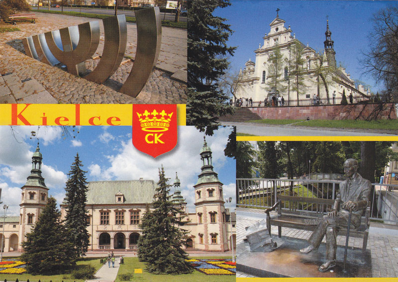
Kielce

Received from: Poland
Category: 6-miesięczny RR
Date: November 2011

Kielce is a city in central Poland with 204,891 inhabitants (June 2009). It is also the capital city of the Świętokrzyskie Voivodeship (Holy Cross Voivodeship) since 1999, previously in Kielce Voivodeship (1919–1939, 1945–1998). The city is located in the middle of the Świętokrzyskie Mountains (Holy Cross Mountains), at the banks of Silnica river, in northern part of the historical Polish province of Lesser Poland. Once an important centre of limestone mining, Kielce is now a centre of trade and commerce.

Wednesday, November 9, 2011

Trzęsacz

Received from: Poland
Category: 6-miesięczny RR
Date: November 2011

Trzęsacz is a village in the administrative district of Gmina Rewal, within Gryfice County, West Pomeranian Voivodeship, in north-western Poland. It lies on the Baltic coast, approximately 2 kilometres (1 mi) west of Rewal, 23 km (14 mi) north-west of Gryfice, and 79 km (49 mi) north of the regional capital Szczecin. Before 1945 the area was part of Germany. For the history of the region, see History of Pomerania. The village has a population of 89. It is a tourist center, famous for its ancient church, which has been reduced over the ages to a lone southern wall.

Zakopane

Received from: Poland
Category: 6-miesięczny RR
Date: November 2011

Zakopane is a town in southern Poland. It lies in the southern part of the Podhale region at the foot of the Tatra Mountains. From 1975 to 1998 it was in of Nowy Sącz Province, but since 1999 it has been in Lesser Poland Province. It had a population of about 28,000 as of 2004. Zakopane is a center of Góral culture and is known informally as "the winter capital of Poland". It is a popular destination for mountaineering, skiing, and tourism.

Saturday, November 5, 2011

Płock

Received from: Poland
Category: 6-miesięczny RR
Date: November 2011

Płock is a city in central Poland, on the Vistula river. According to the data provided by GUS on 30 June 2009 there were 126,675 inhabitants. It is located in the Masovian Voivodeship (since 1999), having previously been the capital of the Płock Voivodeship (1975–1998). It now is a capital of a Powiat (county) at the extreme west of the Mazovian Voivodeship. In years: 1079 - 1138 Płock was capital of Poland. Płock is also a historical capital of Mazovia.

Tricity

Received from: Poland
Category: 6-miesięczny RR
Date: November 2011

Tricity is an urban area consisting of three Polish cities: Gdańsk, Gdynia and Sopot. They are situated adjacent to one other, in a row, on the coast of the Gdańsk Bay, Baltic Sea, in Pomerelia (Pomeranian Voivodeship), northern Poland. The Tricity metropolitan area has a population of over 1 million people. The name Trójmiasto was used informally or semi-formally only, until 28 March 2007, when the "Tricity Charter" (in Polish "Karta Trójmiasta") was signed as a declaration of the cities' cooperation.

Friday, November 4, 2011

Dorset

Received from: United Kingdom
Category: Postcrossing - official card
Date: November 2011
Distance: 1412 km
Time of travelling: 14 days

Dorset is a county in South West England on the English Channel coast. The county town is Dorchester which is situated in the south. The Hampshire towns of Bournemouth and Christchurch joined the county with the reorganisation of local government in 1974. The ceremonial county comprises the area covered by the non-metropolitan county, which is governed by Dorset County Council, together with the unitary authorities of Poole and Bournemouth. Dorset is an average sized county with an area of 2,653 square kilometres (1,024 sq mi); it borders Devon to the west, Somerset to the north-west, Wiltshire to the north-east, and Hampshire to the east. Around half of Dorset's population lives in the South East Dorset conurbation. The rest of the county is largely rural with a low population density.

Odessa

Received from: Ukraine
Category: Postcrossing - official card
Date: November 2011
Distance: 694 km
Time of travelling: 26 days

Odessa or Odesa is the administrative center of the Odessa Oblast (province) located in southern Ukraine. The city is a major seaport located on the northwest shore of the Black Sea and the fourth largest city in Ukraine with a population of 1,029,000 (as of the 2001 census).

Thursday, November 3, 2011

Nuremberg

Received from: Germany
Category: Postcrossing - official card
Date: November 2011
Distance: 842 km
Time of travelling: 77 days

Nuremberg is a city in the German state of Bavaria, in the administrative region of Middle Franconia. Situated on the Pegnitz river and the Rhine–Main–Danube Canal, it is located about 170 kilometres (110 mi) north of Munich and is Franconia's largest city. The population (as of December 2010) is 505,664. The "European Metropolitan Area Nuremberg" has 3.5 million inhabitants.

Lübeck

Received from: Germany
Category: Postcrossing - official card
Date: November 2011
Distance: 716 km
Time of travelling: 5 days

The Hanseatic City of Lübeck is the second-largest city in Schleswig-Holstein, in northern Germany, and one of the major ports of Germany. It was for several centuries the "capital" of the Hanseatic League ("Queen of the Hanse") and, because of its Brick Gothic architectural heritage, is listed by UNESCO as a World Heritage Site. In 2005 it had a population of 213,983.

France

Received from: France
Category: private swap
Date: November 2011

The French Republic is a unitary semi-presidential republic in Western Europe with several overseas territories and islands located on other continents and in the Indian, Pacific, and Atlantic oceans. Metropolitan France extends from the Mediterranean Sea to the English Channel and the North Sea, and from the Rhine to the Atlantic Ocean. It is often referred to as l’Hexagone ("The Hexagon") because of the geometric shape of its territory. It is the largest western European country and it possesses the second-largest Exclusive Economic Zone in the world, covering 11,035,000 km2 (4,260,000 sq mi), just behind that of the United States (11,351,000 km2 / 4,383,000 sq mi).

Minsk

Received from: Belarus
Category: Postcrossing - official card
Date: November 2011
Distance: 474 km
Time of travelling: 12 days

The earliest references to Minsk date to the 11th century (1067), when it was a provincial city within the principality of Polotsk. In 1242, Minsk became a part of the Grand Duchy of Lithuania, and it received its town privileges in 1499. From 1569, it was a capital of the Minsk Voivodship in the Polish–Lithuanian Commonwealth. It was annexed by Russia in 1793, as a consequence of the Second Partition of Poland. From 1919–1991, Minsk was the capital of the Belorussian Soviet Socialist Republic.

Sunday, October 30, 2011

Michigan's Upper Peninsula

Received from: the USA
Category: Postcrossing - official card
Date: October 2011
Distance: 7295 km
Time of travelling: 8 days

The Upper Peninsula of Michigan is the northern of the two major land masses that make up the U.S. state of Michigan. It is commonly referred to as the Upper Peninsula, the U.P., or Upper Michigan. It is also known as the land "above the Bridge" linking the two peninsulas. The peninsula is bounded on the north by Lake Superior, on the east by the St. Mary's River, on the southeast by Lake Michigan and Lake Huron, and on the southwest by Wisconsin.

Rio de Janeiro

Received from: Brazil
Category: private swap
Date: October 2011

Rio de Janeiro, commonly referred to simply as Rio, is the capital city of the State of Rio de Janeiro, the second largest city of Brazil, and the third largest metropolitan area and agglomeration in South America, boasting approximately 6.3 million people within the city proper, making it the 6th largest in the Americas, and 26th in the world.